Land Use Planning
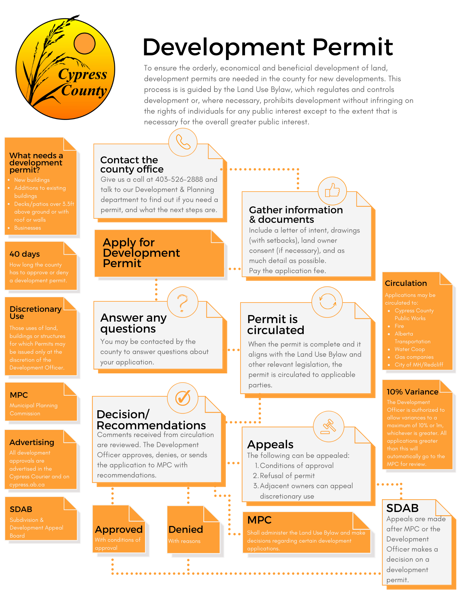 Land use planning is important for any municipality as it ensures appropriate services are available for each resident or business as needed. Council ensures consistency by looking at the large picture, then gradually progressing into detailed land use districts.
South Saskatchewan Regional Plan
The Government of Alberta Land-use Framework (LUF) sets out a new approach to managing the province's land and natural resources to achieve Alberta’s long-term economic, environmental and social goals. One of seven plans under the LUF, the South Saskatchewan Regional Plan (SSRP) establishes a long-term vision, which includes strategies for responsible energy development, sustainable farming and ranching, forest management, and nature-based tourism. It also makes a clear statement about a long-term commitment to conservation, protection of watersheds, sustaining biodiversity and sensitive habitats, and to the continued growth and prosperity of southern Alberta.
Tri-Area Intermunicipal Development Plan (IDP)
Closer to the City of Medicine Hat and the Town of Redcliff, the Tri-Area Intermunicipal Development Plan establishes a regional framework for attracting economic opportunities and managing development in the County near these urban areas. Visit the city's website detailing the update of the new IDP (2025).
Municipal Development Plan
Looking at the county with a very broad view is the Municipal Development Plan (MDP). This bylaw is a statement of goals, objectives and policies regarding land use and development in the county. Agriculture is recognized as the primary land use, but guiding non-agricultural development is very important to prevent conflict between different uses, such as industrial development and residential growth.
Area Structure Plans (ASP)
More specific controls within designated areas are set out in Area Structure Plans. These bylaws specify detailed uses in a defined area without impacting other parts of the county. These plans help ensure road systems, utilities and services such as recreation, are able to support a growing community. Plans are in place for the Cypress Hills Fringe, Desert Blume, Dunmore, Seven Persons, Irvine, Highway 524, Suffield, and Township Road 120.
Land use districts
All land has a defined use. Agriculture is the most general land use and applies typically to the farm and grazing land. More specific land uses would be residential classifications in hamlets, country residential designations for acreages and industrial classes on specific parcels.
All land uses can be changed, if the elected council is convinced it is for the betterment of the county. Amendments to the Land Use Bylaw occur regularly for very small areas or sometimes for individual lots. Ensuring adequate servicing with minimal conflict can sometimes be a difficult balancing act.
Land subdivision
Once a land use is changed, subdivision is often the next step, where a larger parcel of land is divided into two or more smaller parcels. The Municipal Planning Commission reviews each application and upon approval, sets conditions to ensure conformity to the neighbourhood and minimum standards of services.
Engineering guidelines & standards
The county has adopted construction standards & design guidelines which are to be utilized in conjunction with each other. These documents provide specific design requirements and specifications with regards to construction, while still adhering to the requirements of Cypress County policies, the Land Use Bylaw, and applicable provincial and federal legislation. These standards and guidelines are to be applied to all new developments within Cypress County, or in the event repair or maintenance is made to existing infrastructure.
- Dunmore Junction
- Cypress County & County of Newell IDP
- Cypress County & MD of Taber - Intermunicipal Development Plan
- Cypress County Construction Standards
- Cypress County Design Guidelines
- Cypress Hills Fringe Area Structure Plan
- Desert Blume Area Structure Plan
- Dunmore Area Structure Plan
- Highway 524 Area Structure Plan
- Irvine Area Structure Plan
- Seven Persons Area Structure Plan
- South Saskatchewan Regional Plan
- Suffield Area Structure Plan
- Township Road 120 Area Structure Plan